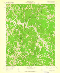
1958 Map of Garretts Bend
USGS Topo · Published 1960About this map
Garretts Bend and the surrounding hollows of West Virginia define this mid-century landscape where four counties — Putnam, Kanawha, Lincoln, and Duval — converge. The map reflects a deeply dissected plateau, where life centered on the winding waters of Trace Fork and Lick Creek. The sheer volume of individual Gas Wells and complex network of pipelines indicates an era of intensive resource extraction that shaped the local economy and road development.
Find a feature on this map
62 named features on this map. Tap any name to fly to it.
Don’t see what you’re looking for? This feature index may not catch every label — zoom into the map to look around manually.
Map Details
Editions of this 1958 Garretts Bend Map
4 editions found
Other maps of this area

1892 · Huntington
USGS Topo · 1:125,000

1898 · Huntington
USGS Topo · 1:125,000

1899 · Charleston
USGS Topo · 1:125,000

1902 · Milton
USGS Topo · 1:62,500

1902 · Midkiff
USGS Topo · 1:62,500

1907 · Midkiff
USGS Topo · 1:62,500

1909 · Midkiff
USGS Topo · 1:62,500

1909 · Saint Albans
USGS Topo · 1:62,500

1911 · Madison
USGS Topo · 1:62,500

1929 · Madison
USGS Topo · 1:62,500