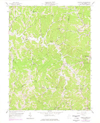
1958 Map of Garretts Bend
USGS Topo · Published 1978About this map
The remote hill country at the intersection of Lincoln, Putnam, and Kanawha Counties comes into focus through this 1958 survey, updated in the 1970s. The settlement of Garretts Bend serves as a local hub near Elizabeth Ch, while the landscape is defined by an intricate network of narrow hollows and ridge-line trails. The area is dense with community markers of a previous generation, including numerous one-room schoolhouses like Sunnydale Sch and Highland Sch, and several rural sanctuaries such as Mt Moriah Ch and Good Hope Ch.
Find a feature on this map
61 named features on this map. Tap any name to fly to it.
Don’t see what you’re looking for? This feature index may not catch every label — zoom into the map to look around manually.
Map Details
Editions of this 1958 Garretts Bend Map
4 editions found
Other maps of this area

1892 · Huntington
USGS Topo · 1:125,000

1898 · Huntington
USGS Topo · 1:125,000

1899 · Charleston
USGS Topo · 1:125,000

1902 · Milton
USGS Topo · 1:62,500

1902 · Midkiff
USGS Topo · 1:62,500

1907 · Midkiff
USGS Topo · 1:62,500

1909 · Midkiff
USGS Topo · 1:62,500

1909 · Saint Albans
USGS Topo · 1:62,500

1911 · Madison
USGS Topo · 1:62,500

1929 · Madison
USGS Topo · 1:62,500