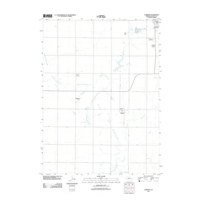
2011 Map of Garrison
USGS Topo · Published 2011About this map
The North Branch Big Blue River winds through this section of Butler County, defining a landscape primarily shaped by agriculture and the grid of rural roads. The village of Garrison serves as a central point, anchored by the Garrison Post Office, while the southern outskirts of David City appear at the northern edge of the survey. The presence of the Bongers Sky Ranch Airfield and several localized settlements like Millerton and Grass Valley Farms reflects the late-twentieth-century rural character of the Nebraska plains.
Find a feature on this map
21 named features on this map. Tap any name to fly to it.
Don’t see what you’re looking for? This feature index may not catch every label — zoom into the map to look around manually.
Map Details
Editions of this 2011 Garrison Map
This is the sole edition of this map. No revisions or reprints were ever made.
Other maps of this area

1899 · David City
USGS Topo · 1:125,000

1955 · Fremont
USGS Topo · 1:250,000

1957 · Fremont
USGS Topo · 1:250,000

1958 · Fremont
USGS Topo · 1:250,000

1958 · Columbus SE
USGS Topo · 1:24,000
1965 · Brainard
USGS Topo · 1:24,000
1965 · Garrison
USGS Topo · 1:24,000
1965 · Rising City
USGS Topo · 1:24,000
1966 · Dwight
USGS Topo · 1:24,000
1966 · Ulysses
USGS Topo · 1:24,000