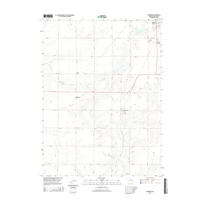
2014 Map of Garrison
USGS Topo · Published 2014About this map
The N Br Big Blue River and its tributary Kezan Cr define the drainage of this central Butler County landscape, where the agricultural grid is intersected by the winding path of Ne-92. To the north, the outskirts of David City reveal a transition from the structured residential blocks of Iowa St and Kansas St to the industrial and transport footprints of the David City Municipal Airport and the David City Cem. The small village of Garrison sits further south, positioned near the intersection of Road KL and Road 30 along the creek. Genealogists will find interest in the documented locations of Pleasant Hill Cem and David City Cem, while the local road network, including Road I and Road H, illustrates the enduring organization of this Nebraska farming region in the early 21st century.
Find a feature on this map
31 named features on this map. Tap any name to fly to it.
Don’t see what you’re looking for? This feature index may not catch every label — zoom into the map to look around manually.
Map Details
Editions of this 2014 Garrison Map
This is the sole edition of this map. No revisions or reprints were ever made.
Other maps of this area

1899 · David City
USGS Topo · 1:125,000

1955 · Fremont
USGS Topo · 1:250,000

1957 · Fremont
USGS Topo · 1:250,000

1958 · Fremont
USGS Topo · 1:250,000

1958 · Columbus SE
USGS Topo · 1:24,000
1965 · Brainard
USGS Topo · 1:24,000
1965 · Garrison
USGS Topo · 1:24,000
1965 · Rising City
USGS Topo · 1:24,000
1966 · Dwight
USGS Topo · 1:24,000
1966 · Ulysses
USGS Topo · 1:24,000