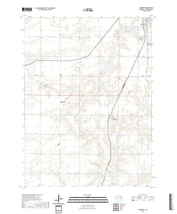
2021 Map of Garrison
USGS Topo · Published 2021About this map
The agricultural heart of Butler County is defined by the winding course of the N Br Big Blue River, which meanders eastward through a landscape of Section-line roads and rural townships. In this 2021 survey, the small community of Garrison sits just south of Holmes St, while the village of Millerton remains a distinct marker along the northern banks of the river. The grid of the county is firmly established by roads like 30 Rd and Rd 31, which connect these isolated settlements to the larger hub of David City visible in the northeast corner.
Find a feature on this map
34 named features on this map. Tap any name to fly to it.
Don’t see what you’re looking for? This feature index may not catch every label — zoom into the map to look around manually.
Map Details
Editions of this 2021 Garrison Map
This is the sole edition of this map. No revisions or reprints were ever made.
Other maps of this area

1899 · David City
USGS Topo · 1:125,000

1955 · Fremont
USGS Topo · 1:250,000

1957 · Fremont
USGS Topo · 1:250,000

1958 · Fremont
USGS Topo · 1:250,000

1958 · Columbus SE
USGS Topo · 1:24,000
1965 · Brainard
USGS Topo · 1:24,000
1965 · Garrison
USGS Topo · 1:24,000
1965 · Rising City
USGS Topo · 1:24,000
1966 · Dwight
USGS Topo · 1:24,000
1966 · Ulysses
USGS Topo · 1:24,000