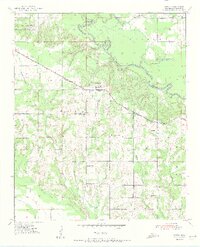
1951 Map of Garvin
USGS Topo · Published 1951About this map
Wheelock Academy stands as a prominent landmark in this corner of McCurtain County, situated northwest of the main settlement at Garvin. The landscape is defined by the winding course of the Little River, which creates distinctive geographical features like Rattlesnake Island and the sharp loop at Possum Ford Bend. Transportation and commerce are anchored by the St Louis San Francisco railroad line, which cuts diagonally across the terrain, serving the local timber and agricultural interests of the mid-20th century.
Find a feature on this map
30 named features on this map. Tap any name to fly to it.
Don’t see what you’re looking for? This feature index may not catch every label — zoom into the map to look around manually.
Map Details
Editions of this 1951 Garvin Map
2 editions found
Other maps of this area

1901 · Alikchi
USGS Topo · 1:125,000

1902 · Lukfata
USGS Topo · 1:125,000

1950 · Mcalester
USGS Topo · 1:250,000

1950 · Idabel
USGS Topo · 1:24,000

1950 · Acworth
USGS Topo · 1:24,000

1951 · Idabel
USGS Topo · 1:24,000

1951 · Garvin
USGS Topo · 1:24,000

1951 · Idabel SE
USGS Topo · 1:24,000

1951 · Acworth
USGS Topo · 1:24,000

1951 · Millerton
USGS Topo · 1:24,000