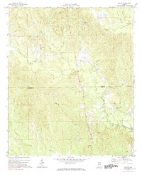
1971 Map of Gaston
USGS Topo · Published 1984About this map
The boundary between Sumter Co and Choctaw Co bisects this rural landscape, which was primarily defined by timber and agriculture during the early 1970s. Small communities like Gaston, Derby, and Cotohaga serve as local hubs, anchored by a high concentration of rural houses of worship such as Gaston Valley Ch, Shorts Ch, and St Johns Ch. The drainage patterns of the region are dominated by Kinterbish Creek and its many tributaries, including Polecat Creek and Cane Creek, which carve through the undulating terrain.
Find a feature on this map
21 named features on this map. Tap any name to fly to it.
Don’t see what you’re looking for? This feature index may not catch every label — zoom into the map to look around manually.
Map Details
Editions of this 1971 Gaston Map
3 editions found
Other maps of this area

1953 · Meridian
USGS Topo · 1:250,000

1957 · Meridian
USGS Topo · 1:250,000

1965 · Meridian
USGS Topo · 1:250,000

1971 · Whitfield
USGS Topo · 1:24,000

1971 · Coatopa
USGS Topo · 1:24,000

1971 · Gaston
USGS Topo · 1:24,000

1971 · Bellamy
USGS Topo · 1:24,000

1974 · Ward
USGS Topo · 1:24,000

1974 · Lisman
USGS Topo · 1:24,000
1974 · York
USGS Topo · 1:24,000