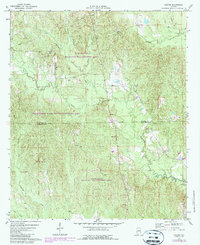
1971 Map of Gaston
USGS Topo · Published 1987About this map
The boundary between Sumter and Choctaw counties runs through the heart of the Kinterbish Wildlife Management Area on this Alabama survey. The landscape is defined by the winding paths of Kinterbish Creek, Cane Creek, and Polecat Creek, which carve through the wooded terrain of west-central Alabama. Small rural settlements like Gaston and Derby anchor the local community, while several traditional meeting places such as Gaston Valley Ch and St Johns Ch provide important landmarks for those researching local family ties. A notable piece of infrastructure, a Pumping Sta near the northern border, reflects the intersection of utility and wilderness. The distribution of Pine Grove Ch and Ward Chapel across the southern half of the map illustrates the scattered, church-centered settlement pattern typical of the era, long before modern development changed the rural character of the region.
Find a feature on this map
22 named features on this map. Tap any name to fly to it.
Don’t see what you’re looking for? This feature index may not catch every label — zoom into the map to look around manually.
Map Details
Editions of this 1971 Gaston Map
3 editions found
Other maps of this area

1953 · Meridian
USGS Topo · 1:250,000

1957 · Meridian
USGS Topo · 1:250,000

1965 · Meridian
USGS Topo · 1:250,000

1971 · Whitfield
USGS Topo · 1:24,000

1971 · Coatopa
USGS Topo · 1:24,000

1971 · Gaston
USGS Topo · 1:24,000

1971 · Bellamy
USGS Topo · 1:24,000

1974 · Ward
USGS Topo · 1:24,000

1974 · Lisman
USGS Topo · 1:24,000
1974 · York
USGS Topo · 1:24,000