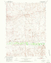
1952 Map of Gates Butte
USGS Topo · Published 1971About this map
Badwater Creek carves a green, vegetated path through the arid landscape of central Wyoming, serving as the primary corridor for movement and settlement in this portion of Fremont County. By the early 1950s, the transit infrastructure was already shifting, as evidenced by the Chicago and North Western (Abandoned) line and the Quincy Ditch (Abandoned), which reflect earlier periods of railroad expansion and irrigation efforts. The landscape is defined by isolated family-named landmarks and sheep ranching stations, including the Gibbs Place and Rate Sheep Camp. High points such as Gates Butte and Gibbs Butte provide clear survey markers across the high desert, while smaller drainage systems like Schoening Creek and Dolus Creek feed into the central valley. This map captures a transition toward specialized livestock operations as the heavy rail influence recedes.
Find a feature on this map
25 named features on this map. Tap any name to fly to it.
Don’t see what you’re looking for? This feature index may not catch every label — zoom into the map to look around manually.
Map Details
Editions of this 1952 Gates Butte Map
3 editions found
Other maps of this area

1952 · Squaw Butte NE
USGS Topo · 1:24,000

1952 · Ocla Draw
USGS Topo · 1:24,000

1952 · Gates Butte
USGS Topo · 1:24,000

1952 · Moneta
USGS Topo · 1:24,000

1952 · Picard Ranch
USGS Topo · 1:24,000

1952 · Lysite
USGS Topo · 1:24,000

1952 · Arapahoe Butte
USGS Topo · 1:24,000

1952 · De Pass
USGS Topo · 1:24,000

1952 · Guffy Peak
USGS Topo · 1:24,000

1955 · Arminto
USGS Topo · 1:250,000