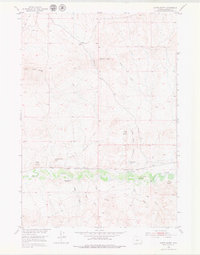
1952 Map of Gates Butte
USGS Topo · Published 1979About this map
Badwater Creek winds through the heart of this central Wyoming landscape, serving as the primary drainage for a network of intermittent waterways including Schoening Creek and Dolus Creek. This mid-century survey, conducted for the development of the Missouri River Basin, reveals a quiet ranching environment defined by its water management and named landforms. Notable features such as Gates Butte, Gibbs Butte, and Day Butte provide distinct landmarks across the high desert terrain. Evidence of former occupation and agricultural infrastructure is present at the Gibbs Place (Aband) and the dry remains of the Chicago Burlington and Quincy Ditch (Aband), reflecting the challenges of maintaining permanent settlements in this arid region north of Cedar Ridge.
Find a feature on this map
18 named features on this map. Tap any name to fly to it.
Don’t see what you’re looking for? This feature index may not catch every label — zoom into the map to look around manually.
Map Details
Editions of this 1952 Gates Butte Map
3 editions found
Other maps of this area

1952 · Squaw Butte NE
USGS Topo · 1:24,000

1952 · Ocla Draw
USGS Topo · 1:24,000

1952 · Gates Butte
USGS Topo · 1:24,000

1952 · Moneta
USGS Topo · 1:24,000

1952 · Picard Ranch
USGS Topo · 1:24,000

1952 · Lysite
USGS Topo · 1:24,000

1952 · Arapahoe Butte
USGS Topo · 1:24,000

1952 · De Pass
USGS Topo · 1:24,000

1952 · Guffy Peak
USGS Topo · 1:24,000

1955 · Arminto
USGS Topo · 1:250,000