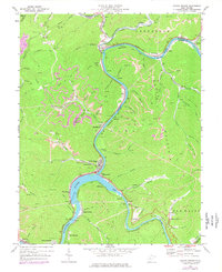
1969 Map of Gauley Bridge
USGS Topo · Published 1977About this map
The confluence of the New River and Gauley River forms the headwaters of the Kanawha River, creating a distinctive industrial and topographical corridor in West Virginia. The town of Gauley Bridge serves as the focal point for this intersection, where steep mountain terrain forced the concentration of rail and road infrastructure. The influence of the Chesapeake and Ohio and Conrail lines is evident throughout the river valleys, supporting the region's extraction and power industries. Numerous small settlements such as Glen Ferris, Swiss, and Belva are scattered along these transport routes.
Find a feature on this map
87 named features on this map. Tap any name to fly to it.
Don’t see what you’re looking for? This feature index may not catch every label — zoom into the map to look around manually.
Map Details
Editions of this 1969 Gauley Bridge Map
3 editions found

Other maps of this area

1897 · Kanawha Falls
USGS Topo · 1:125,000

1900 · Kanawha Falls
USGS Topo · 1:125,000

1901 · Kanawha Falls
USGS Topo · 1:125,000

1907 · Clendenin
USGS Topo · 1:62,500

1908 · Clay
USGS Topo · 1:48,000

1908 · Fayetteville
USGS Topo · 1:48,000

1908 · Montgomery
USGS Topo · 1:48,000

1909 · Clendenin
USGS Topo · 1:62,500

1910 · Clay
USGS Topo · 1:62,500

1910 · Fayetteville
USGS Topo · 1:62,500