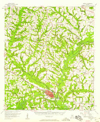
1957 Map of Geneva
USGS Topo · Published 1958About this map
Geneva sits at the confluence of the Choctawhatchee River and the Pea River, protected by a prominent Levee system. This late 1950s landscape reflects a settled agricultural region in southeastern Alabama, where the Louisville and Nashville RR cuts through the river valley to connect the county seat with outlying communities like Bellwood and Black. The map captures a high density of rural social centers, including Marvin Chapel, St James Ch, and the Church of Peace, alongside localized industry represented by Schuttle Mill and Vahlandingham Mill. Local infrastructure is further detailed by the Landing Field south of the city and the Geneva County Lake to the west. From the Flowing Well near the river to the numerous family burial grounds like McDuffie Cem, the map documents the established community footprints before modern highway expansion altered the rural layout.
Find a feature on this map
109 named features on this map. Tap any name to fly to it.
Don’t see what you’re looking for? This feature index may not catch every label — zoom into the map to look around manually.
Map Details
Editions of this 1957 Geneva Map
2 editions found

Other maps of this area

1942 · Enterprise
USGS Topo · 1:125,000

1948 · Ozark
USGS Topo · 1:62,500

1949 · Glendale
USGS Topo · 1:62,500

1949 · Hobbs Crossroads
USGS Topo · 1:24,000

1950 · Ozark
USGS Topo · 1:62,500

1950 · Hobbs Cross Roads
USGS Topo · 1:24,000

1950 · Enterprise
USGS Topo · 1:62,500

1950 · Izagora
USGS Topo · 1:24,000

1950 · Esto
USGS Topo · 1:24,000

1951 · Esto
USGS Topo · 1:24,000