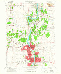
1964 Map of Geneva
USGS Topo · Published 1965About this map
The Fox River anchors this mid-century portrait of suburban expansion, winding through the interconnected communities of St Charles and Geneva. Educational and religious institutions are particularly prominent along the river corridor, including St Dominic College, Mount St Mary Academy, and Sacred Heart Seminary. The landscape reflects a transition from rural agricultural land to residential estates, seen in developments like Fox River Estates and Valley View. Transportation networks define the area's growth, with the Illinois Central Railroad and Chicago and North Western lines crossing the terrain. Notable local landmarks such as Vasa Park and the Fabyan Forest Preserve offer a look at the preserved open spaces and recreation areas that defined the Fox River valley during this period of significant development.
Find a feature on this map
82 named features on this map. Tap any name to fly to it.
Don’t see what you’re looking for? This feature index may not catch every label — zoom into the map to look around manually.
Map Details
Editions of this 1964 Geneva Map
4 editions found
Other maps of this area

1908 · Wheaton
USGS Topo · 1:62,500

1923 · Barrington
USGS Topo · 1:62,500

1925 · Elgin
USGS Topo · 1:62,500

1932 · Geneva
USGS Topo · 1:62,500

1935 · Barrington
USGS Topo · 1:62,500

1940 · Elgin
USGS Topo · 1:62,500

1948 · Wheaton
USGS Topo · 1:62,500

1948 · Geneva
USGS Topo · 1:62,500

1949 · Geneva
USGS Topo · 1:24,000

1950 · Aurora North
USGS Topo · 1:24,000