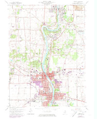
1964 Map of Geneva
USGS Topo · Published 1973About this map
The Fox River valley serves as the central corridor for this mid-century survey, anchoring the growing communities of St Charles and Geneva. Purple-tinted urban extensions reflect the early 1970s residential expansion around established landmarks like Mount St Mary Academy and the Courthouse. The landscape is notably institutional, featuring the State Training Sch for Boys on the western edge and the State Training Sch for Girls to the south. Educational and religious sites are dense along the river bluffs, including St Dominic College and Sacred Heart Seminary. Industrial activity is represented by various Gravel Pits and the proximity of the Du Page County Airport on the eastern boundary. This era captures the transition of formerly agricultural lands into suburban tracts, such as Fox River Estates and Novak Park, while preserving significant green space at the Pratts Wayne Woods Forest Preserve.
Find a feature on this map
75 named features on this map. Tap any name to fly to it.
Don’t see what you’re looking for? This feature index may not catch every label — zoom into the map to look around manually.
Map Details
Editions of this 1964 Geneva Map
4 editions found
Other maps of this area

1908 · Wheaton
USGS Topo · 1:62,500

1923 · Barrington
USGS Topo · 1:62,500

1925 · Elgin
USGS Topo · 1:62,500

1932 · Geneva
USGS Topo · 1:62,500

1935 · Barrington
USGS Topo · 1:62,500

1940 · Elgin
USGS Topo · 1:62,500

1948 · Wheaton
USGS Topo · 1:62,500

1948 · Geneva
USGS Topo · 1:62,500

1949 · Geneva
USGS Topo · 1:24,000

1950 · Aurora North
USGS Topo · 1:24,000