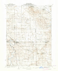
1938 Map of Genoa
USGS Topo · Published 1938About this map
The Kishwaukee River and its South Branch define the drainage of this Northern Illinois landscape, where several major rail lines intersect at the edge of the 1930s. The Chicago Milwaukee St Paul and Pacific and the Chicago Great Western railroads cross near Genoa, establishing the town as a vital shipping point for the surrounding dairy and agricultural lands. The presence of numerous named rural schoolhouses, such as Derby Line Sch and Hickory Grove Sch, illustrates the dense pattern of small farmsteads that once supported a decentralized education system before the era of modern consolidation. Small hamlets like Kingston and New Lebanon anchor the landscape, while the North Kingston Cem and Ney Ch serve as enduring markers of early community life. The surveying also captures the early footprints of Illinois 2 and Illinois 13 as they began to modernize the region’s transit.
Find a feature on this map
74 named features on this map. Tap any name to fly to it.
Don’t see what you’re looking for? This feature index may not catch every label — zoom into the map to look around manually.
Map Details
Editions of this 1938 Genoa Map
3 editions found

Other maps of this area

1918 · Belvidere
USGS Topo · 1:62,500

1918 · Kirkland
USGS Topo · 1:62,500

1925 · Elgin
USGS Topo · 1:62,500

1926 · Mc Henry
USGS Topo · 1:62,500

1932 · Harvard
USGS Topo · 1:48,000

1932 · Geneva
USGS Topo · 1:62,500

1934 · De Kalb
USGS Topo · 1:62,500

1937 · De Kalb
USGS Topo · 1:62,500

1937 · Sycamore
USGS Topo · 1:62,500

1937 · Harvard
USGS Topo · 1:62,500