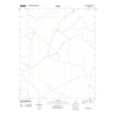
2010 Map of George Ranch
USGS Topo · Published 2010About this map
George Ranch and Roark Ranch anchor this landscape in Guadalupe County, where family ranching operations define the settlement pattern of the high plains. The terrain is marked by seasonal watercourses like Pintada Arroyo and the sweeping Leoncito Draw, which cut through the open country. Transportation across these stretches is facilitated by Mesa De Leon Rd and County Rd-4, linking the dispersed ranch sites. To the northeast, the landform transitions at Milagro Canyon, while the small settlement of Martinez appears in the southeast corner. This 2010 survey illustrates the enduring nature of New Mexico's rural ranching heritage, showing how named locations often correspond to single family holdings rather than dense towns.
Find a feature on this map
9 named features on this map. Tap any name to fly to it.
Don’t see what you’re looking for? This feature index may not catch every label — zoom into the map to look around manually.
Map Details
Editions of this 2010 George Ranch Map
This is the sole edition of this map. No revisions or reprints were ever made.
Other maps of this area

1954 · Fort Sumner
USGS Topo · 1:250,000

1958 · Fort Sumner
USGS Topo · 1:250,000
1978 · Milagro Spring
USGS Topo · 1:24,000
1978 · George Ranch
USGS Topo · 1:24,000

1978 · Mesa Leon
USGS Topo · 1:24,000
1978 · Tapia Ranch
USGS Topo · 1:24,000
1978 · Pintada
USGS Topo · 1:24,000

1978 · Santa Barbara Lake
USGS Topo · 1:24,000
1978 · Milagro
USGS Topo · 1:24,000
1978 · Pinavete Canyon
USGS Topo · 1:24,000