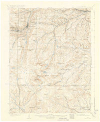
1905 Map of Georgetown
USGS Topo · Published 1934About this map
Georgetown and Silver Plume serve as the industrial anchors of this high-altitude survey, illustrating the complex rail and mining infrastructure of the early 1900s. The world-famous Georgetown Loop and the ambitious Argentine Central Ry wind through steep grades, connecting the valley settlements to productive sites like the Stanley Mines and the scattered camps of Freeland and Lamartine. The landscape is dominated by the massive profile of Mt Evans, surrounded by a network of alpine waters including Chicago Lakes and Summit Lake. Topographer Frank Tweedy recorded a region in transition, where the heavy industry of the Pike National Forest headwaters, indicated by features like the Tramway, begins to meet the early recreational footprint seen at Beaver Meadows Camp and the Bear Creek Ranger Sta.
Find a feature on this map
115 named features on this map. Tap any name to fly to it.
Don’t see what you’re looking for? This feature index may not catch every label — zoom into the map to look around manually.
Map Details
Editions of this 1905 Georgetown Map
5 editions found
Other maps of this area

1893 · Platte Canyon
USGS Topo · 1:125,000

1899 · West Denver
USGS Topo · 1:125,000

1903 · Georgetown
USGS Topo · 1:62,500

1905 · Central City
USGS Topo · 1:62,500

1905 · Georgetown
USGS Topo · 1:62,500

1906 · Blackhawk
USGS Topo · 1:62,500

1910 · Central City
USGS Topo · 1:62,500

1912 · Central City
USGS Topo · 1:62,500

1924 · Montezuma
USGS Topo · 1:62,500

1924 · Fraser
USGS Topo · 1:62,500