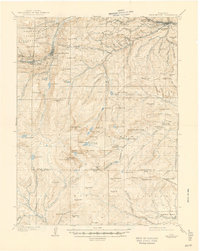
1905 Map of Georgetown
USGS Topo · Published 1945About this map
Georgetown and Silver Plume anchor the high mountain landscape of this 1903 survey, connected by the famous engineering of the Georgetown Loop and served by the Argentine Central RR. The map documents a transition from established mining centers like Idaho Springs and Freeland to the high-altitude wilderness of the Arapaho National Forest. At the center of the sheet, Mt Evans dominates a cluster of glacial features including Summit Lake, Lake Abyss, and the Chicago Lakes.
Find a feature on this map
98 named features on this map. Tap any name to fly to it.
Don’t see what you’re looking for? This feature index may not catch every label — zoom into the map to look around manually.
Map Details
Editions of this 1905 Georgetown Map
5 editions found
Other maps of this area

1893 · Platte Canyon
USGS Topo · 1:125,000

1899 · West Denver
USGS Topo · 1:125,000

1903 · Georgetown
USGS Topo · 1:62,500

1905 · Central City
USGS Topo · 1:62,500

1905 · Georgetown
USGS Topo · 1:62,500

1906 · Blackhawk
USGS Topo · 1:62,500

1910 · Central City
USGS Topo · 1:62,500

1912 · Central City
USGS Topo · 1:62,500

1924 · Montezuma
USGS Topo · 1:62,500

1924 · Fraser
USGS Topo · 1:62,500