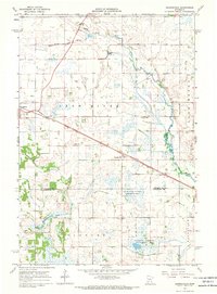
1967 Map of Georgeville
USGS Topo · Published 1969About this map
The Soo Line railroad creates a sharp diagonal axis across this central Minnesota landscape, connecting the village of Belgrade with the smaller settlement of Georgeville. This 1960s survey reveals a region defined by complex hydrology and land management, where the North Fork Crow River, Middle Fork Crow River, and South Fork Crow River meander through a terrain dense with wetlands and engineered drainage. Numerous county ditches, such as County Ditch No 8 and County Ditch No 5, illustrate the extensive efforts to manage the water table for agriculture and conservation. Dedicated wildlife spaces are prominent, including the Follies State Wildlife Management Area and a significant National Wildlife Management Area. Local heritage is anchored by sites like St Francis de Sales Cem and Gandal Cem, while the presence of several Gravel Pits points to the area's local surfacing industries.
Find a feature on this map
25 named features on this map. Tap any name to fly to it.
Don’t see what you’re looking for? This feature index may not catch every label — zoom into the map to look around manually.
Map Details
Editions of this 1967 Georgeville Map
This is the sole edition of this map. No revisions or reprints were ever made.
Other maps of this area

1953 · Saint Cloud
USGS Topo · 1:250,000

1957 · Saint Cloud
USGS Topo · 1:250,000

1958 · Saint Cloud
USGS Topo · 1:250,000

1965 · Greenwald
USGS Topo · 1:24,000

1965 · Padua
USGS Topo · 1:24,000

1965 · Elrosa
USGS Topo · 1:24,000

1967 · Mount Tom
USGS Topo · 1:24,000

1967 · Belgrade
USGS Topo · 1:24,000

1967 · Hawick
USGS Topo · 1:24,000
1967 · Lake Henry
USGS Topo · 1:24,000