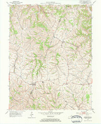
1952 Map of Germantown
USGS Topo · Published 1983About this map
Germantown sits astride the Bracken Co Mason Co line in this early 1950s survey, serving as a central hub for the surrounding agricultural community. The landscape is defined by a dense network of winding waterways, including Bracken Creek, Lee Creek, and Locust Creek, which carve through the terrain and dictate the placement of early rural roads. To the east, the settlement of Minerva and the smaller community of Fernleaf anchor the Mason County side, while the local Fairgrounds east of Germantown point to the area's social and economic focus on livestock and farming.
Find a feature on this map
20 named features on this map. Tap any name to fly to it.
Don’t see what you’re looking for? This feature index may not catch every label — zoom into the map to look around manually.
Map Details
Editions of this 1952 Germantown Map
2 editions found
Other maps of this area

1915 · Maysville
USGS Topo · 1:62,500

1919 · Maysville
USGS Topo · 1:62,500

1928 · Higginsport
USGS Topo · 1:48,000

1931 · Felicity
USGS Topo · 1:62,500

1931 · Higginsport
USGS Topo · 1:62,500

1952 · Germantown
USGS Topo · 1:24,000

1952 · Higginsport
USGS Topo · 1:24,000

1952 · Maysville West
USGS Topo · 1:24,000

1952 · Sardis
USGS Topo · 1:24,000

1952 · Mount Olivet
USGS Topo · 1:24,000