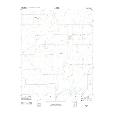
2009 Map of Gerty
USGS Topo · Published 2009About this map
Gerty serves as the primary settlement hub in this rural Oklahoma landscape, defined by its small grid of streets and the nearby Gerty Cemetery. The surrounding terrain is heavily influenced by the drainage basins of Big Sandy Creek and Panther Creek, which converge toward the southern boundary at Muddy Boggy Creek. Industrial activity is localized at the Ne Citra Oil and Gas Field, highlighting the region's extraction-based economy. Numerous small reservoirs and water management features are scattered across the quadrangle, including the L J Shepard Dam, Mike Russell Dam, and several unnamed impoundments. Genealogy researchers will find the Panther Creek Cemetery isolated in the southern reaches, connected to the larger community by a network of sectional roads such as N S 378 RD and E W 150 RD.
Find a feature on this map
44 named features on this map. Tap any name to fly to it.
Don’t see what you’re looking for? This feature index may not catch every label — zoom into the map to look around manually.
Map Details
Editions of this 2009 Gerty Map
This is the sole edition of this map. No revisions or reprints were ever made.
Other maps of this area

1896 · Coalgate
USGS Topo · 1:125,000

1899 · Coalgate
USGS Topo · 1:125,000

1900 · Coalgate
USGS Topo · 1:125,000

1957 · Tupelo NE
USGS Topo · 1:24,000

1957 · Ardmore
USGS Topo · 1:250,000

1958 · Lula
USGS Topo · 1:24,000

1958 · Steedman
USGS Topo · 1:24,000

1963 · Ardmore
USGS Topo · 1:250,000

1967 · Calvin East
USGS Topo · 1:24,000
1967 · Non
USGS Topo · 1:24,000