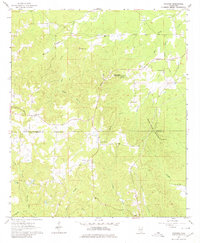
1963 Map of Gholson
USGS Topo · Published 1980About this map
The ridge-and-hollow landscape of the Noxubee Co Kemper Co border region is defined here by several prominent peaks, including Gholson Mountain, Hit Mountain, and White House Mountain. In the early 1960s, the rural community of Gholson stood as a central point in this network of timbered hills and creeks. The map provides significant detail for local historians, documenting the location of Poorhouse Mountain and its associated Poorhouse Spring and Poorhouse Cem. These labels indicate a historical social infrastructure that had become part of the local geography.
Find a feature on this map
32 named features on this map. Tap any name to fly to it.
Don’t see what you’re looking for? This feature index may not catch every label — zoom into the map to look around manually.
Map Details
Editions of this 1963 Gholson Map
3 editions found

Other maps of this area

1953 · Meridian
USGS Topo · 1:250,000

1953 · West Point
USGS Topo · 1:250,000

1957 · Meridian
USGS Topo · 1:250,000

1958 · West Point
USGS Topo · 1:250,000

1962 · Lynville
USGS Topo · 1:24,000

1962 · Preston
USGS Topo · 1:24,000

1962 · Shuqualak
USGS Topo · 1:24,000

1963 · West Point
USGS Topo · 1:250,000

1963 · De Kalb
USGS Topo · 1:24,000

1963 · Townsend
USGS Topo · 1:24,000