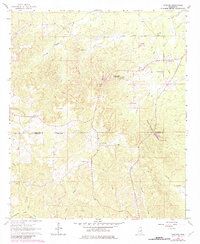
1963 Map of Gholson
USGS Topo · Published 1982About this map
Gholson and the surrounding high ground of the Noxubee and Kemper County line are captured here during a period of transition in east-central Mississippi. The landscape is defined by a series of prominent rises including Hit Mountain, Gholson Mountain, and Poorhouse Mountain, where Poorhouse Spring and Poorhouse Cemetery indicate a former site of county-level social infrastructure. This 1963 survey, with later 1980 photorevisions, documents the legacy of early 20th-century transportation through the lingering Old Railroad Grade that cuts through the eastern portion of the quadrangle.
Find a feature on this map
31 named features on this map. Tap any name to fly to it.
Don’t see what you’re looking for? This feature index may not catch every label — zoom into the map to look around manually.
Map Details
Editions of this 1963 Gholson Map
3 editions found

Other maps of this area

1953 · Meridian
USGS Topo · 1:250,000

1953 · West Point
USGS Topo · 1:250,000

1957 · Meridian
USGS Topo · 1:250,000

1958 · West Point
USGS Topo · 1:250,000

1962 · Lynville
USGS Topo · 1:24,000

1962 · Preston
USGS Topo · 1:24,000

1962 · Shuqualak
USGS Topo · 1:24,000

1963 · West Point
USGS Topo · 1:250,000

1963 · De Kalb
USGS Topo · 1:24,000

1963 · Townsend
USGS Topo · 1:24,000