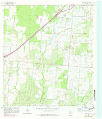
1964 Map of Ghost Hill
USGS Topo · Published 1982About this map
The Medina Co Frio Co line cuts through this South Texas landscape, where the Missouri Pacific railroad runs parallel to a series of gravel operations and industrial sites. The topography is defined by the namesake Ghost Hill and an extensive network of waterways, including San Miguel Creek and Black Creek, which drain toward the south. This area demonstrates a mid-century energy economy, anchored by the Big Foot Oil Field and the Big Foot Gas Field in the southern reaches of the quadrangle.
Find a feature on this map
19 named features on this map. Tap any name to fly to it.
Don’t see what you’re looking for? This feature index may not catch every label — zoom into the map to look around manually.
Map Details
Editions of this 1964 Ghost Hill Map
2 editions found
Other maps of this area

1927 · Pearsall
USGS Topo · 1:62,500

1934 · Schattel
USGS Topo · 1:62,500

1942 · Natalia
USGS Topo · 1:62,500

1953 · Crystal City
USGS Topo · 1:250,000

1954 · San Antonio
USGS Topo · 1:250,000

1955 · Crystal City
USGS Topo · 1:250,000

1957 · San Antonio
USGS Topo · 1:250,000

1961 · Crystal City
USGS Topo · 1:250,000

1964 · Ghost Hill
USGS Topo · 1:24,000

1964 · Devine
USGS Topo · 1:24,000