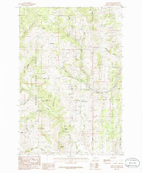
1986 Map of Giant Hill
USGS Topo · Published 1986About this map
Placer and lode mining claims define the landscape of this Broadwater County region in the mid-1980s, particularly around the Giant Hill Prospects and the Limestone Hills. The map shows a transition from the wooded slopes of the Helena National Forest to more arid, gulch-cut terrain further east. Remote settlements like Hassel and Mc Mullan appear alongside evidence of heavy industry, including numerous Mine Shafts, Tailings, and Adits scattered near Ribedeau Gulch and Badger Gulch.
Find a feature on this map
47 named features on this map. Tap any name to fly to it.
Don’t see what you’re looking for? This feature index may not catch every label — zoom into the map to look around manually.
Map Details
Editions of this 1986 Giant Hill Map
This is the sole edition of this map. No revisions or reprints were ever made.
Other maps of this area

1886 · Fort Logan
USGS Topo · 1:250,000

1948 · White Sulphur Springs
USGS Topo · 1:250,000

1949 · Radersburg
USGS Topo · 1:62,500

1950 · Devils Fence
USGS Topo · 1:62,500

1950 · Townsend
USGS Topo · 1:62,500

1950 · Clancy
USGS Topo · 1:62,500

1958 · White Sulphur Springs
USGS Topo · 1:250,000

1961 · White Sulphur Springs
USGS Topo · 1:250,000

1965 · White Sulphur Springs
USGS Topo · 1:250,000

1976 · Townsend
USGS Topo · 1:100,000