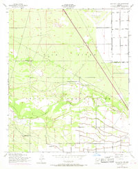
1952 Map of Gila Butte NW
USGS Topo · Published 1968About this map
The Gila River Indian Reservation dominates this landscape, showing a complex network of agriculture and infrastructure along the banks of the Gila River. Small communities and spiritual centers like Snaketown, Bapchule, St Francis Borgia Ch, and an Adventist Ch are connected by a grid of rural routes including Rittenhouse Road and Price Road. The terrain is shaped by water management, with a prominent Levee system protecting the surrounding fields and settlements from the river's seasonal shifts.
Find a feature on this map
24 named features on this map. Tap any name to fly to it.
Don’t see what you’re looking for? This feature index may not catch every label — zoom into the map to look around manually.
Map Details
Editions of this 1952 Gila Butte NW Map
3 editions found

Other maps of this area

1912 · Phoenix
USGS Topo · 1:62,500

1913 · Mesa
USGS Topo · 1:62,500

1913 · Maricopa
USGS Topo · 1:62,500

1914 · Gila Butte
USGS Topo · 1:62,500

1914 · Phoenix
USGS Topo · 1:62,500

1915 · Mesa
USGS Topo · 1:62,500

1915 · Maricopa
USGS Topo · 1:62,500

1917 · Gila Butte
USGS Topo · 1:62,500

1952 · Gila Butte SE
USGS Topo · 1:24,000

1952 · Maricopa
USGS Topo · 1:24,000