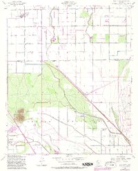
1952 Map of Gila Butte
USGS Topo · Published 1982About this map
Gila Butte rises prominently above the valley floor, serving as a landmark within the Gila River Indian Reservation Boundary during the mid-20th century. The landscape is defined by the contrast between organized agricultural development north of the Hunt Highway and the more traditional settlement patterns along the Gila River to the south. Extensive irrigation infrastructure, including the Eastern Canal and the Consolidated Canal, supported the cotton and citrus fields of Ocotillo and Hamilton Corner, while the Southern Pacific railroad provided the vital connection to regional markets.
Find a feature on this map
34 named features on this map. Tap any name to fly to it.
Don’t see what you’re looking for? This feature index may not catch every label — zoom into the map to look around manually.
Map Details
Editions of this 1952 Gila Butte Map
4 editions found

Other maps of this area

1904 · Desert Well
USGS Topo · 1:62,500

1906 · Desert Well
USGS Topo · 1:62,500

1907 · Sacaton
USGS Topo · 1:62,500

1913 · Mesa
USGS Topo · 1:62,500

1914 · Gila Butte
USGS Topo · 1:62,500

1915 · Mesa
USGS Topo · 1:62,500

1917 · Gila Butte
USGS Topo · 1:62,500

1952 · Gila Butte SE
USGS Topo · 1:24,000

1952 · Chandler
USGS Topo · 1:24,000

1952 · Sacaton Butte
USGS Topo · 1:24,000