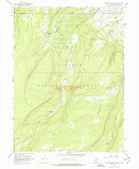
1967 Map of Gilbert Peak NE
USGS Topo · Published 1977About this map
Wasatch National Forest dominates this landscape along the high border between Summit County and the Wyoming state line in the late 1960s. The region is defined by the industrial presence of the Bridger Lake Oil Field, where scattered oil wells and oil sumps are situated amidst high-elevation parks and glacial lakes. The drainage of Henrys Fork carves through the center of the map, passing through a topographic constriction known as The Narrows and supporting the Henrys Fork Campground.
Find a feature on this map
30 named features on this map. Tap any name to fly to it.
Don’t see what you’re looking for? This feature index may not catch every label — zoom into the map to look around manually.
Map Details
Editions of this 1967 Gilbert Peak NE Map
3 editions found
Other maps of this area

1885 · Uinta
USGS Topo · 1:250,000

1905 · Gilbert Peak
USGS Topo · 1:125,000

1906 · Gilbert Peak
USGS Topo · 1:125,000

1954 · Salt Lake City
USGS Topo · 1:250,000

1954 · Ogden
USGS Topo · 1:250,000

1958 · Ogden
USGS Topo · 1:250,000

1958 · Salt Lake City
USGS Topo · 1:250,000

1960 · Ogden
USGS Topo · 1:250,000

1960 · Salt Lake City
USGS Topo · 1:250,000
1964 · Lonetree
USGS Topo · 1:24,000