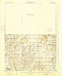
1925 Map of Gilman
USGS Topo · Published 1925About this map
The Quincy Omaha and Kansas City railroad cuts across the northwestern corner of this 1920s landscape, serving as a primary corridor through northwestern Missouri. The area is characterized by a dense network of rural infrastructure, where nearly every township section is anchored by a named schoolhouse or church. Significant community hubs include the settlement of Jameson and the village of Bancroft.
Find a feature on this map
49 named features on this map. Tap any name to fly to it.
Don’t see what you’re looking for? This feature index may not catch every label — zoom into the map to look around manually.
Map Details
Editions of this 1925 Gilman Map
3 editions found
Other maps of this area

1921 · Chillicothe
USGS Topo · 1:62,500

1922 · Gallatin
USGS Topo · 1:62,500

1923 · Chillicothe
USGS Topo · 1:62,500

1924 · Winston
USGS Topo · 1:62,500

1925 · Pattonsburg
USGS Topo · 1:62,500

1925 · Gilman
USGS Topo · 1:62,500

1944 · Pattonsburg
USGS Topo · 1:62,500

1946 · Gilman
USGS Topo · 1:48,000

1946 · Pattonsburg
USGS Topo · 1:48,000

1946 · Princeton
USGS Topo · 1:62,500