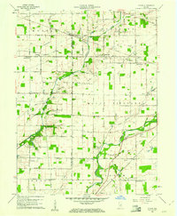
1960 Map of Gilman
USGS Topo · Published 1960About this map
The Madison and Delaware county line divides this Indiana landscape, where the White River winds through the southern reaches near Daleville. In the early 1960s, this area maintained a dense network of rural landmarks, from the Vermillion Meetinghouse in the northwest to the remote Pikes Peak Ch in the southeast. The terrain is defined by the drainage of Killbuck Creek and its many tributaries, including Moon Branch and Pleasant Run. Small settlements and railroad stops like Gilman and Reed Station punctuate the grid of section roads, while several family and community burial grounds, such as Janes Cem and Heagy Cem, provide significant points of interest for genealogical research. The presence of the Chicago and St Louis RR and the New York Central RR highlights the region's historical reliance on rail transport to connect these agricultural townships.
Find a feature on this map
67 named features on this map. Tap any name to fly to it.
Don’t see what you’re looking for? This feature index may not catch every label — zoom into the map to look around manually.
Map Details
Editions of this 1960 Gilman Map
5 editions found
Other maps of this area

1952 · Muncie West
USGS Topo · 1:24,000

1952 · Anderson
USGS Topo · 1:24,000

1953 · Muncie
USGS Topo · 1:250,000

1956 · Muncie
USGS Topo · 1:250,000

1960 · Gilman
USGS Topo · 1:24,000

1960 · Middletown
USGS Topo · 1:24,000

1960 · Alexandria
USGS Topo · 1:24,000

1960 · Wheeling
USGS Topo · 1:24,000

1960 · Sulphur Springs
USGS Topo · 1:24,000

1960 · Gaston
USGS Topo · 1:24,000