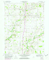
1960 Map of Gilman
USGS Topo · Published 1982About this map
The White River winds through the southern reaches of this landscape, anchoring a rural territory where agriculture and small rail-side settlements define the mid-century geography. Established gathering places like the Vermillion Meetinghouse and Vermillion Ch serve as local anchors for the dispersed farming community. The movement of goods and people is dictated by the Norfolk And Western and Conrail lines, which connect small hubs like Reed Station and Gilman to the broader regional economy.
Find a feature on this map
50 named features on this map. Tap any name to fly to it.
Don’t see what you’re looking for? This feature index may not catch every label — zoom into the map to look around manually.
Map Details
Editions of this 1960 Gilman Map
5 editions found
Other maps of this area

1952 · Muncie West
USGS Topo · 1:24,000

1952 · Anderson
USGS Topo · 1:24,000

1953 · Muncie
USGS Topo · 1:250,000

1956 · Muncie
USGS Topo · 1:250,000

1960 · Gilman
USGS Topo · 1:24,000

1960 · Middletown
USGS Topo · 1:24,000

1960 · Alexandria
USGS Topo · 1:24,000

1960 · Wheeling
USGS Topo · 1:24,000

1960 · Sulphur Springs
USGS Topo · 1:24,000

1960 · Gaston
USGS Topo · 1:24,000