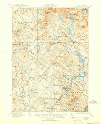
1927 Map of Gilmanton
USGS Topo · Published 1950About this map
Shaker Village and the rural townships of Belmont and Gilmanton define this landscape during a period of established agricultural and early industrial activity. The map reveals a dense network of country roads connecting small settlement hubs such as Gilmanton Ironworks and Websters Mills, reflecting the importance of water power and local industry. Educational and spiritual life is well-documented through numerous district institutions, including the Upper City School, Gales School, and the historic Smith Meetinghouse.
Find a feature on this map
139 named features on this map. Tap any name to fly to it.
Don’t see what you’re looking for? This feature index may not catch every label — zoom into the map to look around manually.
Map Details
Editions of this 1927 Gilmanton Map
5 editions found
Other maps of this area

1909 · Winnepesaukee
USGS Topo · 1:62,500

1917 · Mt. Pawtuckaway
USGS Topo · 1:62,500

1919 · Mt. Pawtuckaway
USGS Topo · 1:62,500

1919 · Gilmanton
USGS Topo · 1:62,500

1919 · Alton
USGS Topo · 1:62,500

1921 · Suncook
USGS Topo · 1:62,500

1925 · Holderness
USGS Topo · 1:62,500

1927 · Concord
USGS Topo · 1:62,500

1927 · Penacook
USGS Topo · 1:62,500

1927 · Gilmanton
USGS Topo · 1:62,500