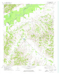
1972 Map of Gilt Edge
USGS Topo · Published 1974About this map
Hatchie River meanders through the northwest corner of this West Tennessee landscape, defining the boundary between Lauderdale and Tipton Counties. The terrain is characterized by the prominent Chickasaw Bluff No 1 and the lowlands of the Western Valley, creating a varied topography that influenced early settlement patterns. This 1970s survey documents a network of rural communities such as Gilt Edge, Burlison, and Garland, each anchored by central meeting places like Kelley Chapel and Elm Grove Ch.
Find a feature on this map
40 named features on this map. Tap any name to fly to it.
Don’t see what you’re looking for? This feature index may not catch every label — zoom into the map to look around manually.
Map Details
Editions of this 1972 Gilt Edge Map
2 editions found
Other maps of this area

1942 · Millington
USGS Topo · 1:62,500

1954 · Mason
USGS Topo · 1:62,500

1956 · Blytheville
USGS Topo · 1:250,000

1959 · Blytheville
USGS Topo · 1:250,000

1960 · Millington
USGS Topo · 1:62,500

1961 · Rialto
USGS Topo · 1:62,500

1962 · Rialto
USGS Topo · 1:62,500

1963 · Osceola
USGS Topo · 1:62,500

1965 · Osceola
USGS Topo · 1:62,500

1965 · Brighton
USGS Topo · 1:24,000