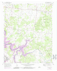
1956 Map of Gladeville
USGS Topo · Published 1987About this map
The dense woodlands of the Cedars of Lebanon State Forest and the sprawling waters of J Percy Priest Lake define this central Tennessee landscape along the Wilson and Rutherford county lines. In the mid-1970s, this area reflects a mix of conservation and military influence, anchored by the presence of Sewart Air Force Base and residential developments like Stones River Homes. The settlement at Gladeville serves as a local hub, connected by historic thoroughfares such as Stewart Ferry Pike and Couchville Pike.
Find a feature on this map
41 named features on this map. Tap any name to fly to it.
Don’t see what you’re looking for? This feature index may not catch every label — zoom into the map to look around manually.
Map Details
Editions of this 1956 Gladeville Map
5 editions found

Other maps of this area

1903 · Nashville
USGS Topo · 1:125,000

1916 · Murfreesboro
USGS Topo · 1:62,500

1932 · Hermitage
USGS Topo · 1:62,500

1942 · Lebanon
USGS Topo · 1:100,000

1950 · Walterhill
USGS Topo · 1:24,000

1951 · Lebanon
USGS Topo · 1:24,000

1951 · Martha
USGS Topo · 1:24,000

1952 · Hermitage
USGS Topo · 1:24,000

1952 · La Vergne
USGS Topo · 1:24,000

1956 · Vine
USGS Topo · 1:24,000