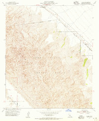
1955 Map of Glamis
USGS Topo · Published 1955About this map
Glamis sits at the northern edge of this mid-century desert landscape, serving as a vital waypoint along the Southern Pacific railroad line. The map captures a moment when the shifting terrain of the Sand Hills met the tactical requirements of the era, dominated by the expansive Naval Reservation Boundary and its designated Impact Range. This military presence is etched across the dunes, defined by coordinates and man-made structures like the Dike that redirect the sparse desert hydrology.
Find a feature on this map
12 named features on this map. Tap any name to fly to it.
Don’t see what you’re looking for? This feature index may not catch every label — zoom into the map to look around manually.
Map Details
Editions of this 1955 Glamis Map
4 editions found
Other maps of this area

1903 · Yuma
USGS Topo · 1:125,000

1905 · Yuma
USGS Topo · 1:125,000

1907 · Holtville
USGS Topo · 1:125,000

1942 · El Centro
USGS Topo · 1:250,000

1942 · Yuma
USGS Topo · 1:250,000

1942 · Blythe
USGS Topo · 1:250,000

1953 · Quartz Peak
USGS Topo · 1:62,500

1953 · Ogilby
USGS Topo · 1:62,500

1953 · Cactus
USGS Topo · 1:24,000

1953 · Acolita
USGS Topo · 1:24,000