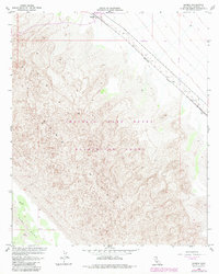
1955 Map of Glamis
USGS Topo · Published 1983About this map
The Southern Pacific railroad corridor cuts a sharp diagonal across this arid landscape, serving as the primary lifeline between the isolated outposts of Glamis and Ruthven. This 1955 survey, with photorevisions through the late 1970s, captures the stark geography of the Sand Hills and the extensive Imperial Sand Dunes Recreation Lands. The terrain is defined by complex dune formations and the broad, open expanse of East Mesa, where a network of Jeep Trails and several prominent Dikes provide the only significant landmarks beyond the steel rails. The mapping reflects a region defined by its harsh environment and the infrastructure required to traverse it, offering a clear record of the transportation and recreation patterns in this corner of the California desert.
Find a feature on this map
9 named features on this map. Tap any name to fly to it.
Don’t see what you’re looking for? This feature index may not catch every label — zoom into the map to look around manually.
Map Details
Editions of this 1955 Glamis Map
4 editions found
Other maps of this area

1903 · Yuma
USGS Topo · 1:125,000

1905 · Yuma
USGS Topo · 1:125,000

1907 · Holtville
USGS Topo · 1:125,000

1942 · El Centro
USGS Topo · 1:250,000

1942 · Yuma
USGS Topo · 1:250,000

1942 · Blythe
USGS Topo · 1:250,000

1953 · Quartz Peak
USGS Topo · 1:62,500

1953 · Ogilby
USGS Topo · 1:62,500

1953 · Cactus
USGS Topo · 1:24,000

1953 · Acolita
USGS Topo · 1:24,000