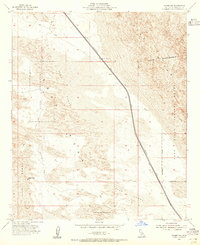
1954 Map of Glamis NW
USGS Topo · Published 1955About this map
The Coachella Canal dominates this mid-century desert landscape, cutting a sharp line across the shifting sands of Imperial County. This engineering feat, accompanied by infrastructure such as Coachella Bridge No 2 and a Gaging Sta, represents the mid-century effort to move water through the arid Colorado Desert. Much of the surrounding terrain is defined by the Sand Hills and Mesa Sand Dunes, where the lack of permanent roads is signaled by a network of Jeep Trails. A large portion of the eastern and southern territory is designated as a Naval Reservation, reflecting the military importance of this remote region for training and testing during the post-war era. Landmarks are few in this topography, though Deer Peak and several surveyed benchmarks like BM 114 serve as vital points of reference.
Find a feature on this map
19 named features on this map. Tap any name to fly to it.
Don’t see what you’re looking for? This feature index may not catch every label — zoom into the map to look around manually.
Map Details
Editions of this 1954 Glamis NW Map
3 editions found
Other maps of this area

1907 · Holtville
USGS Topo · 1:125,000

1940 · Iris
USGS Topo · 1:62,500

1940 · Alamorio
USGS Topo · 1:62,500

1942 · El Centro
USGS Topo · 1:250,000

1945 · Alamorio
USGS Topo · 1:62,500

1945 · Iris
USGS Topo · 1:62,500

1953 · Acolita
USGS Topo · 1:24,000

1953 · Acolita
USGS Topo · 1:62,500

1954 · El Centro
USGS Topo · 1:250,000

1954 · Salton Sea
USGS Topo · 1:250,000