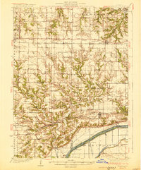
1930 Map of Glasford
USGS Topo · Published 1930About this map
Kingston Mines and the lowlands bordering the Illinois River define the industrial and agricultural landscape of this late-1920s survey. The area is characterized by a dense network of coal operations, including the Newsom Mine and Lightbody Mine, situated where the bluff meets the river plain. Settlement patterns follow the railroads, with the Toledo Peoria and Western and Minneapolis and St Louis lines connecting towns like Hanna City and Glasford.
Find a feature on this map
87 named features on this map. Tap any name to fly to it.
Don’t see what you’re looking for? This feature index may not catch every label — zoom into the map to look around manually.
Map Details
Editions of this 1930 Glasford Map
3 editions found
Other maps of this area

1893 · Dunlap
USGS Topo · 1:62,500

1898 · Dunlap
USGS Topo · 1:62,500

1905 · Peoria
USGS Topo · 1:62,500

1912 · Canton
USGS Topo · 1:62,500

1925 · Havana
USGS Topo · 1:62,500

1927 · Peoria
USGS Topo · 1:62,500

1929 · Manito
USGS Topo · 1:62,500

1930 · Glasford
USGS Topo · 1:62,500

1932 · Dunlap
USGS Topo · 1:62,500

1932 · Manito
USGS Topo · 1:62,500