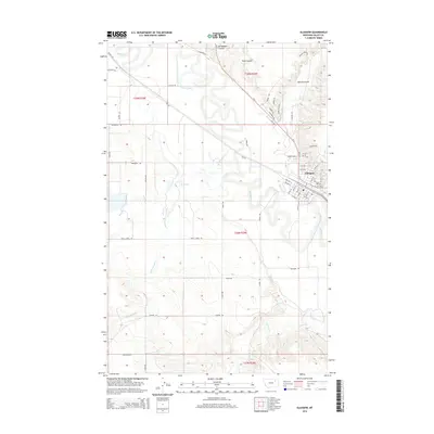
2014 Map of Glasgow
USGS Topo · Published 2014About this map
Glasgow stands as the primary hub of this eastern Montana landscape, where the meandering Milk River dictates the region's geography and drainage. The city is detailed with its street grid north and south of the river, while the surrounding plains are marked by a network of drainage features including Brazil Cr, Cherry Cr, and Willow Cr. Named topographic features such as Richardson Coulee, Rock Coulee, and Martin Coulee define the rising ground to the north and east, illustrating the erosion patterns of the Missouri River watershed. Land ownership and agricultural history are represented by sites like Engstrom Ranch and a complex system of rural routes, including Brazil Creek Rd, Hagen Rd, and Giddion Rd, which connect the scattered homesteads and townships of this vast high-plains environment.
Find a feature on this map
61 named features on this map. Tap any name to fly to it.
Don’t see what you’re looking for? This feature index may not catch every label — zoom into the map to look around manually.
Map Details
Editions of this 2014 Glasgow Map
This is the sole edition of this map. No revisions or reprints were ever made.
Other maps of this area

1943 · Glasgow
USGS Topo · 1:125,000

1954 · Glasgow
USGS Topo · 1:250,000

1957 · Glasgow
USGS Topo · 1:250,000

1958 · Glasgow
USGS Topo · 1:250,000

1958 · Engstrom Ranch
USGS Topo · 1:24,000

1958 · Miller Coulee
USGS Topo · 1:62,500

1958 · Glasgow
USGS Topo · 1:24,000
1958 · Blanchard Ranch
USGS Topo · 1:24,000

1958 · Wheeler
USGS Topo · 1:24,000

1958 · Whately
USGS Topo · 1:24,000