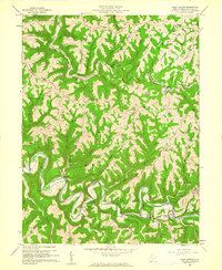
1960 Map of Glen Easton
USGS Topo · Published 1961About this map
Grave Creek and the Baltimore and Ohio Railroad wind through the northern portion of this Marshall County landscape, passing the notable landmark of Rosbys Rock. This 1960 survey illustrates a deeply dissected plateau where ridge-top farming and narrow hollows dictate the pattern of settlement. Tight meanders of Fish Creek dominate the southern half of the sheet, carving around Sallys Ridge and Backbone Ridge near the small communities of Meighen and Adaline.
Find a feature on this map
82 named features on this map. Tap any name to fly to it.
Don’t see what you’re looking for? This feature index may not catch every label — zoom into the map to look around manually.
Map Details
Editions of this 1960 Glen Easton Map
3 editions found
Other maps of this area

1903 · Littleton
USGS Topo · 1:62,500

1904 · Cameron
USGS Topo · 1:62,500

1905 · Littleton
USGS Topo · 1:62,500

1905 · Clarington
USGS Topo · 1:62,500

1906 · New Martinsville
USGS Topo · 1:62,500

1924 · New Martinsville
USGS Topo · 1:62,500

1924 · Littleton
USGS Topo · 1:62,500

1926 · Littleton
USGS Topo · 1:62,500

1926 · New Martinsville
USGS Topo · 1:62,500

1935 · Cameron
USGS Topo · 1:62,500