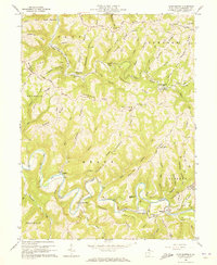
1960 Map of Glen Easton
USGS Topo · Published 1973About this map
The Baltimore and Ohio railroad corridor anchors this 1960s study of Marshall County, winding through the sharp valley of Grave Creek past the village of Rosbys Rock. To the south, the deep, meandering oxbows of Fish Creek define the geography near settlements like Meighen, Lynn Camp, and Adaline. The landscape is a complex network of narrow ridges and hollows, where family-named landmarks such as Shoestring Ridge, Roberts Ridge, and Games Ridge separate the various watersheds.
Find a feature on this map
75 named features on this map. Tap any name to fly to it.
Don’t see what you’re looking for? This feature index may not catch every label — zoom into the map to look around manually.
Map Details
Editions of this 1960 Glen Easton Map
3 editions found
Other maps of this area

1903 · Littleton
USGS Topo · 1:62,500

1904 · Cameron
USGS Topo · 1:62,500

1905 · Littleton
USGS Topo · 1:62,500

1905 · Clarington
USGS Topo · 1:62,500

1906 · New Martinsville
USGS Topo · 1:62,500

1924 · New Martinsville
USGS Topo · 1:62,500

1924 · Littleton
USGS Topo · 1:62,500

1926 · Littleton
USGS Topo · 1:62,500

1926 · New Martinsville
USGS Topo · 1:62,500

1935 · Cameron
USGS Topo · 1:62,500