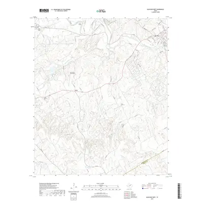
2019 Map of Glen Rose West
USGS Topo · Published 2019About this map
Glen Rose serves as the focal point for this survey of the northern edges of the Texas Hill Country, where the Paluxy River winds eastward through a complex network of creeks and limestone drainages. The landscape is defined by the intersection of rural aviation and historic community landmarks, with both the Rancho Hielo Brazos Airport and the Circle P Ranch Airport positioned near sprawling ranch lands. Genealogists will find significant value in the distribution of family-named burial grounds across the terrain, including Lanham Mill Cem near the riverbanks and the Nancy Smith Cem located further west near the settlement of Glass. The northern reaches are characterized by a growing recreational infrastructure, featuring an extensive trail system that includes the Buckeye Trail, Cedar Brake Outer Loop Trail, and the Horseshoe Equestrian Trail. These paths, alongside named drainages like Mustang Cr and White Bluff Cr, illustrate the transition from agricultural use to modern leisure and residential development.
Find a feature on this map
71 named features on this map. Tap any name to fly to it.
Don’t see what you’re looking for? This feature index may not catch every label — zoom into the map to look around manually.
Map Details
Editions of this 2019 Glen Rose West Map
This is the sole edition of this map. No revisions or reprints were ever made.
Other maps of this area

1889 · Granbury
USGS Topo · 1:125,000

1924 · Granbury 1-c
USGS Topo · 1:48,000

1928 · Godley
USGS Topo · 1:62,500

1931 · Morgan
USGS Topo · 1:62,500

1931 · Tolar
USGS Topo · 1:62,500

1954 · Dallas
USGS Topo · 1:250,000

1958 · Dallas
USGS Topo · 1:250,000
1961 · Hill City
USGS Topo · 1:24,000
1961 · Nemo
USGS Topo · 1:24,000
1961 · Paluxy
USGS Topo · 1:24,000