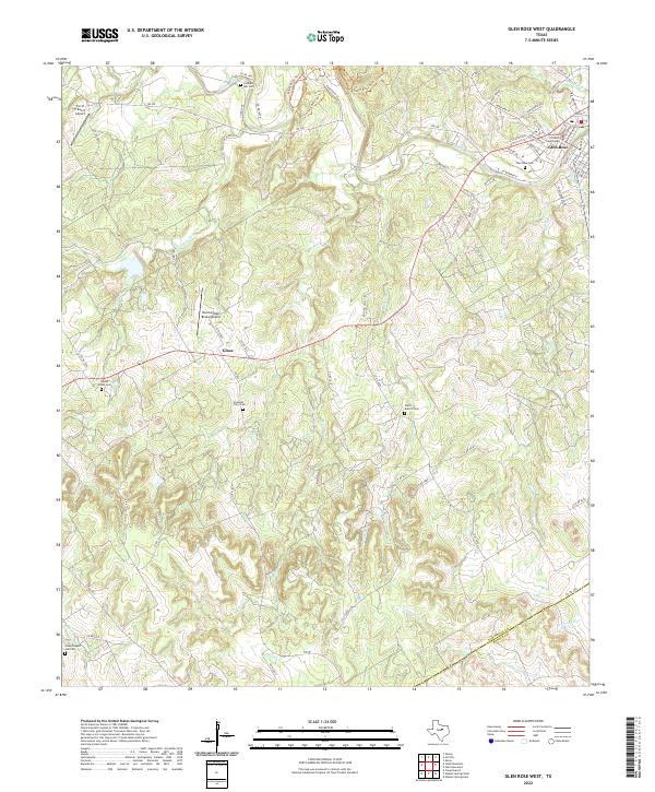
2022 Map of Glen Rose West
USGS Topo · Published 2022About this map
The Paluxy River winds through the heart of the landscape, defining the character of the area west of Glen Rose. This modern-era survey shows a region rich in family and local history, anchored by the Somervell County Courthouse and numerous burial grounds such as Lanham Mill Cem and the Nancy Smith Cem. The terrain is marked by significant drainages including White Bluff Cr and Ice Cr, which cut through the Rolling Hills toward the river valley.
Find a feature on this map
71 named features on this map. Tap any name to fly to it.
Don’t see what you’re looking for? This feature index may not catch every label — zoom into the map to look around manually.
Map Details
Editions of this 2022 Glen Rose West Map
This is the sole edition of this map. No revisions or reprints were ever made.
Other maps of this area

1889 · Granbury
USGS Topo · 1:125,000

1924 · Granbury 1-c
USGS Topo · 1:48,000

1928 · Godley
USGS Topo · 1:62,500

1931 · Morgan
USGS Topo · 1:62,500

1931 · Tolar
USGS Topo · 1:62,500

1954 · Dallas
USGS Topo · 1:250,000

1958 · Dallas
USGS Topo · 1:250,000
1961 · Hill City
USGS Topo · 1:24,000
1961 · Nemo
USGS Topo · 1:24,000
1961 · Paluxy
USGS Topo · 1:24,000