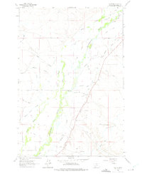
1961 Map of Glen SE
USGS Topo · Published 1975About this map
The Beaverhead River valley in the early 1960s was defined by a complex network of man-made irrigation features supporting a productive agricultural landscape. This survey reveals an intricate hydraulic system including the West Side Canal, the East Bench Canal, and numerous family-named waterways such as Staudaher Ditch and Malley Ditch. These ditches weave through a terrain naturally marked by meandering watercourses like Albers Slough and Willard Slough, reflecting the intensive water management required to cultivate this part of Montana.
Find a feature on this map
34 named features on this map. Tap any name to fly to it.
Don’t see what you’re looking for? This feature index may not catch every label — zoom into the map to look around manually.
Map Details
Editions of this 1961 Glen SE Map
4 editions found
Other maps of this area

1893 · Dillon
USGS Topo · 1:250,000

1955 · Dillon
USGS Topo · 1:250,000

1957 · Dillon
USGS Topo · 1:250,000

1958 · Dillon
USGS Topo · 1:250,000

1960 · Glen
USGS Topo · 1:24,000

1960 · Block Mountain
USGS Topo · 1:24,000

1961 · Glen SE
USGS Topo · 1:24,000

1961 · Christensen Ranch
USGS Topo · 1:24,000

1962 · Dillon
USGS Topo · 1:250,000
1962 · Beaverhead Rock
USGS Topo · 1:24,000