1956 Map of Glencoe
USGS Topo · Published 1973About this map
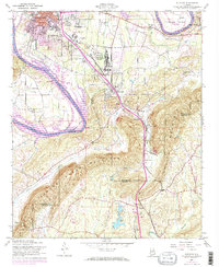
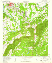
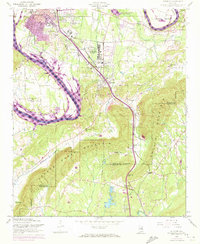
The Gadsden Air Force Depot anchors the central valley of this mid-century landscape, positioned between the expanding industrial reach of Gadsden and the residential growth of Glencoe. The industrial character of the era is evident in features like the Aqueduct, Oil Disposal Pits, and numerous quarries scattered near the Louisville and Nashville railroad tracks. These rail lines serve as a vital corridor, connecting the northern urban centers to rural southern outposts like Cobb City and Colwell.
Find a feature on this map
50 named features on this map. Tap any name to fly to it.
Don’t see what you’re looking for? This feature index may not catch every label — zoom into the map to look around manually.
Map Details
Editions of this 1956 Glencoe Map
3 editions found
Other maps of this area

1885 · Gadsden
USGS Topo · 1:125,000

1888 · Gadsden
USGS Topo · 1:125,000

1889 · Springville
USGS Topo · 1:125,000

1892 · Springville
USGS Topo · 1:125,000

1892 · Gadsden
USGS Topo · 1:125,000

1893 · Fort Payne
USGS Topo · 1:125,000

1895 · Gadsden
USGS Topo · 1:125,000

1898 · Fort Payne
USGS Topo · 1:125,000

1900 · Fort Payne
USGS Topo · 1:125,000

1900 · Anniston
USGS Topo · 1:125,000