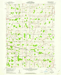
1960 Map of Glenmore
USGS Topo · Published 1961About this map
West of the city of Van Wert, this 1960 topographic study reveals a productive landscape defined by the intersection of rural agriculture and heavy rail. The Erie Lackawanna Railroad and the Chicago and New York Railroad cut through the terrain, anchoring small settlements like Glenmore and Abanaka. These rail lines were the lifeblood of the local economy, connecting grain-producing fields and small-scale industrial sites like the Tile Factory to larger markets.
Find a feature on this map
37 named features on this map. Tap any name to fly to it.
Don’t see what you’re looking for? This feature index may not catch every label — zoom into the map to look around manually.
Map Details
Editions of this 1960 Glenmore Map
2 editions found
Other maps of this area

1911 · Berne
USGS Topo · 1:48,000

1914 · Celina
USGS Topo · 1:62,500

1914 · Van Wert
USGS Topo · 1:62,500

1944 · Van Wert
USGS Topo · 1:62,500

1944 · Celina
USGS Topo · 1:62,500

1953 · Muncie
USGS Topo · 1:250,000

1956 · Muncie
USGS Topo · 1:250,000
1960 · Convoy
USGS Topo · 1:24,000

1960 · Dixon
USGS Topo · 1:24,000
1960 · Scott
USGS Topo · 1:24,000