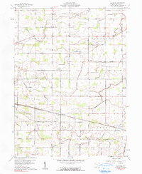
1960 Map of Glenmore
USGS Topo · Published 1990About this map
The unincorporated settlement of Glenmore serves as a central point in this Van Wert County survey, situated at the crossing of the Erie Lackawanna Railroad and Glenmore Road. The landscape is a textbook example of the American Midwest's rural grid, dominated by family-named landmarks and essential community institutions like St Thomas Sch and Antioch Ch. Small clusters such as Middlebury and Maddox dot the intersections of a dense network of county roads including Zook Road and Kreischer Road.
Find a feature on this map
47 named features on this map. Tap any name to fly to it.
Don’t see what you’re looking for? This feature index may not catch every label — zoom into the map to look around manually.
Map Details
Editions of this 1960 Glenmore Map
2 editions found
Other maps of this area

1911 · Berne
USGS Topo · 1:48,000

1914 · Celina
USGS Topo · 1:62,500

1914 · Van Wert
USGS Topo · 1:62,500

1944 · Van Wert
USGS Topo · 1:62,500

1944 · Celina
USGS Topo · 1:62,500

1953 · Muncie
USGS Topo · 1:250,000

1956 · Muncie
USGS Topo · 1:250,000
1960 · Convoy
USGS Topo · 1:24,000

1960 · Dixon
USGS Topo · 1:24,000
1960 · Scott
USGS Topo · 1:24,000