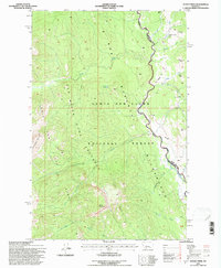
1995 Map of Glenn Creek
USGS Topo · Published 1997About this map
Lewis and Clark National Forest encompasses this high-altitude landscape, where the confluence of major drainage systems defines the movement of water and wildlife. The map documents the protected lands of the Bob Marshall Wilderness and the Sun River Game Preserve, showing a terrain largely undisturbed by modern road networks. Steep elevations are anchored by Slategoat Mountain and Sheep Mountain, while narrow valleys carry the North Fork Sun River and Glenn Creek through the heart of the region. The map reveals the intricate drainage patterns of the South Fork Bear Creek and Bob Creek, alongside isolated landmarks such as Hazard Lake and the Sulphur Creek Lick. Human presence is minimal, noted primarily by primitive routes like the Two Shacks Trail and the boundary line separating Teton and Lewis and Clark counties.
Find a feature on this map
26 named features on this map. Tap any name to fly to it.
Don’t see what you’re looking for? This feature index may not catch every label — zoom into the map to look around manually.
Map Details
Editions of this 1995 Glenn Creek Map
This is the sole edition of this map. No revisions or reprints were ever made.
Other maps of this area

1903 · Saypo
USGS Topo · 1:125,000

1936 · Silvertip
USGS Topo · 1:96,000

1942 · Silvertip
USGS Topo · 1:125,000

1955 · Choteau
USGS Topo · 1:250,000

1957 · Choteau
USGS Topo · 1:250,000

1958 · Choteau
USGS Topo · 1:250,000

1958 · Our Lake
USGS Topo · 1:24,000

1958 · Glenn Creek
USGS Topo · 1:24,000

1958 · Pretty Prairie
USGS Topo · 1:24,000

1958 · Gates Park
USGS Topo · 1:24,000