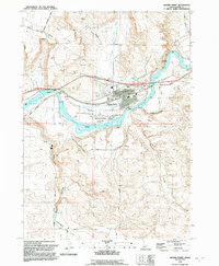
1992 Map of Glenns Ferry
USGS Topo · Published 1992About this map
Glenns Ferry sits as a critical nexus of transport and water management on the northern bank of the Snake River. This 1990s revision reveals a landscape where the historical path of the Oregon Trail and the industrial backbone of the Union Pacific railroad converge near Three Island Crossing. The area is characterized by complex irrigation systems, including an aqueduct, flume, and multiple siphons that move water across the dissected terrain of Little Canyon Creek and Alkali Creek. Beyond the town center, the map details the local infrastructure of the County Fairgrounds, a municipal Airport, and the Three Island Crossing State Park. To the south, the terrain rises into the draws of Rosevear Gulch and the basalt-rimmed canyons of Deadman Creek, where Deadman Falls marks a sharp break in the volcanic plateau of Deadman Flat.
Find a feature on this map
42 named features on this map. Tap any name to fly to it.
Don’t see what you’re looking for? This feature index may not catch every label — zoom into the map to look around manually.
Map Details
Editions of this 1992 Glenns Ferry Map
This is the sole edition of this map. No revisions or reprints were ever made.
Other maps of this area

1892 · Camas Prairie
USGS Topo · 1:125,000

1893 · Camas Prairie
USGS Topo · 1:125,000

1947 · Hammett
USGS Topo · 1:24,000

1947 · Glenns Ferry
USGS Topo · 1:24,000

1947 · Pasadena Valley
USGS Topo · 1:24,000

1948 · Pasadena Valley
USGS Topo · 1:24,000

1948 · Hammett
USGS Topo · 1:24,000

1948 · Glenns Ferry
USGS Topo · 1:24,000

1948 · Twentymile Butte
USGS Topo · 1:24,000

1948 · Glenns Ferry
USGS Topo · 1:62,500