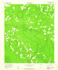
1958 Map of Glennville SE
USGS Topo · Published 1961About this map
Rural Long County is defined by a network of creeks and small settlements in the late 1950s. The landscape is dominated by the lowlands of Vinzant Swamp and numerous watercourses like Beards Creek and Jones Creek. A prominent diagonal scar across the terrain represents the Old Railroad Grade, which passes through the community of Donald. This infrastructure highlights the transition from rail-dependent timber or agricultural transport to the road-based network seen at Smiley Crossroads.
Find a feature on this map
22 named features on this map. Tap any name to fly to it.
Don’t see what you’re looking for? This feature index may not catch every label — zoom into the map to look around manually.
Map Details
Editions of this 1958 Glennville SE Map
2 editions found
Other maps of this area

1918 · Jesup
USGS Topo · 1:62,500

1918 · Hinesville
USGS Topo · 1:62,500

1920 · Glennville
USGS Topo · 1:62,500

1943 · Ludowici
USGS Topo · 1:62,500

1943 · Jesup
USGS Topo · 1:62,500

1944 · Glennville
USGS Topo · 1:62,500

1944 · Hinesville
USGS Topo · 1:62,500

1946 · Brunswick
USGS Topo · 1:250,000

1948 · Brunswick
USGS Topo · 1:250,000

1950 · Glennville
USGS Topo · 1:62,500